Analyzing satellite image collections
on public cloud platforms with R
CONAE spring school 2022
Marius Appel
Sept. 27, 2022
Motivation
Data availability (e.g. Sentinel-2) in the cloud
Method availability (e.g. in R, > 18k CRAN packages)
Who wants to download > 100 GB from data portals?
Tutorial overview
Objective: Show how you can analyze satellite image collections in the cloud with R
- Introduction:
- Cloud computing
- Satellite imagery in the cloud
- Cloud-native geospatial echnologies
- R ecosystem
- Live examples
- Creating composite images
- Complex time series analysis
- Extraction from data cubes
- Discussion
All materials are available on GitHub: https://github.com/appelmar/CONAE_2022.
1. The cloud
“… in the cloud”
Services:
Infrastructure providers:
- Amazon web services (AWS)
- Google Cloud Platform
- Microsoft Azure
- …
Somewhere in between: Microsoft Planetary Computer
In this tutorial, we will use a custom machine on AWS to analyze satellite image collections in the cloud.
Cloud infrastructure (AWS)
- Lots of separate data centers with large clusters

- In total: > 25 regions and > 80 availability zones
- Basic service to run (virtual) machines: EC2 (Amazon Elastic Compute Cloud)
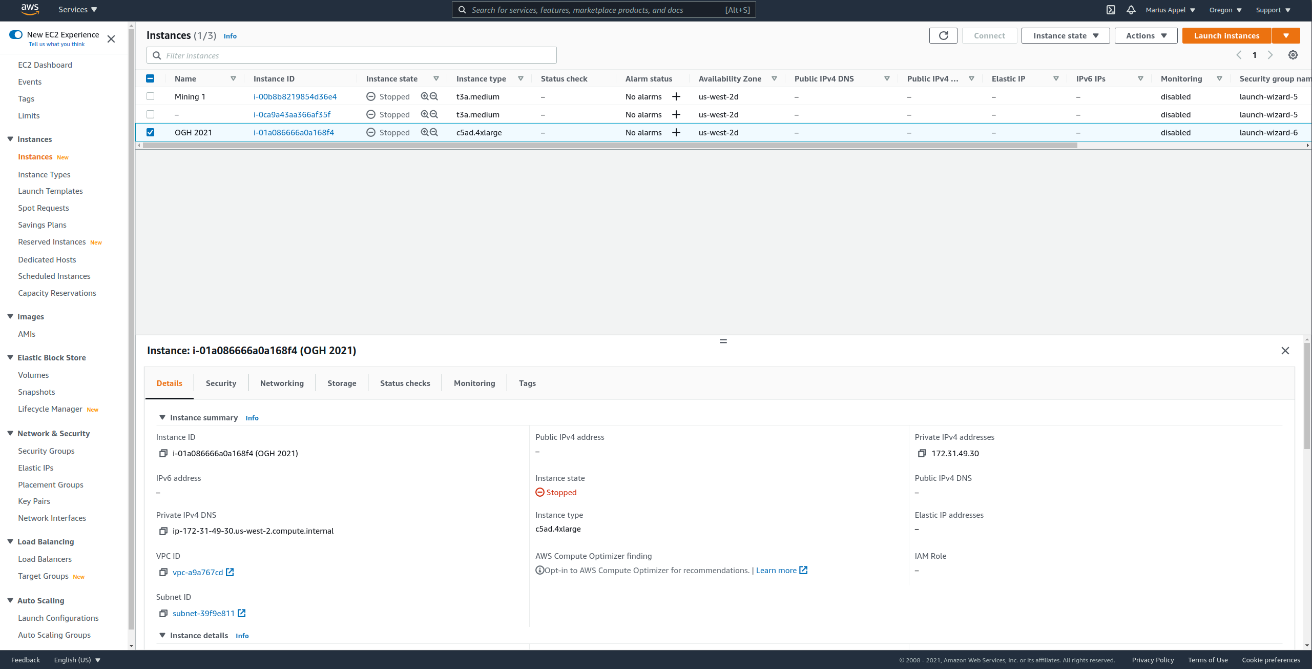
Running a machine in the cloud (AWS)
Select a region and machine instance type, based on costs, hardware, and OS
Create a key pair for accessing the machine over SSH
Click “Launch instance” and follow instructions
Connect via SSH and install software (PROJ, GDAL, R, RStudioServer1, R packages, …)
Notice that security considerations (e.g. by using IAM roles, multi-factor authorization) are NOT part of this tutorial.
AWS Management Console
2. Satellite imagery on cloud platforms
Example platforms and available data
| Provider | Data |
|---|---|
| Amazon web services (AWS) | Sentinel, Landsat, ERA 5, OSM, CMIP 6, and more, see here |
| Google Cloud Platform | Landsat, Sentinel, access to GEE data |
| Microsoft Planetary Computer | Sentinel, Landsat, MODIS and more, see here |
Object Storage: S3
EC2 machines have local storage (EBS) but big data archives use highly scalable object storage.
S3 elements:
- Bucket: container for objects that are stored in a specific AWS region
- Objects: Individual files and corresponding metadata within a bucket, identified by a unique key
- Key: Filenames / Path or similar; unique within a bucket
Pricing (storage, transfer, requests):
- Bucket owner pays by default
- For requester pays buckets, transfer and requests are paid by users
S3 examples
Buckets:
Object:
Data access
- Buckets are not a drive on your machine
- Data access over HTTP requests (PUT, GET, DELETE, …)
Challenges
How to find images by location, time, and other criteria?
How to efficiently read image data from S3 without copying images to our machine storage first?
3. Cloud-native geospatial: STAC, COGs, and data cubes
STAC overview
Standardized JSON-based language for describing catalogs of spatiotemporal data (imagery, point clouds, SAR)
Extensible (available extensions include EO, Data Cubes, Point Clouds, and more)
1.0.0 release available since May 2021
Growing ecosystem

STAC specification
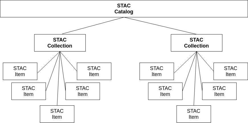
- Items are inseparable objects of data (assets) and metadata (e.g. a single satellite image)
- Catalogs can be nested
- Collections extend catalogs and can be used to group items and their metadata (e.g. license)
STAC API
Static STAC catalogs
- Typically set of linked JSON files, starting with a
catalog.json - Catalog JSON contains links to collections, nested catalogs, or items
- Items contain assets (links to files) and metadata
- Problem: All items must be processed for searching
- Example: https://meeo-s5p.s3.amazonaws.com/catalog.json
STAC API
- Web-service for dynamic search of STAC items by area of interest, datetime, and other metadata
- Compliant with OGC API - Features standard
STAC Index
- A good starting point to find available STAC collections and API services: https://stacindex.org
Cloud-optimized GeoTIFF (COG)
Image file formats must be cloud-friendly to reduce transfer times and costs associated with transfer and requests
COG = Normal tiled GeoTIFF files whose content follows a specific order of data and metadata (see full spec here)
support compression
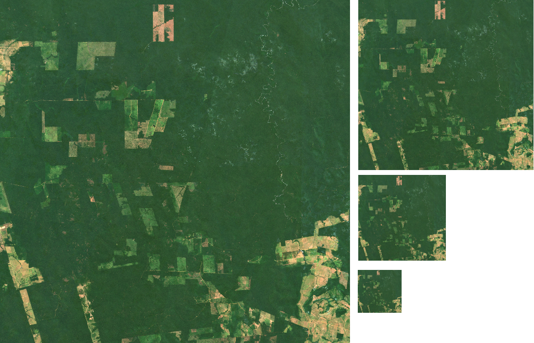
support efficient HTTP range requests, i.e. partial reading of images (blocks, and overviews) over cloud storage
may contain overview images (image pyramids)
GDAL can efficiently read and write COGs, and access object storage in the cloud with virtual file systems
Satellite image collections
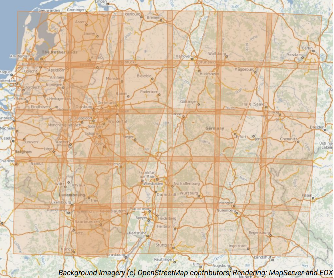
Images spatially overlap, have different coordinate reference systems, have different pixel sizes depending on spectral bands, yield irregular time series for larger areas
What is a data cube?
Here: A four-dimensional (space, time, variable / band) regular raster data cube

- collect all observations in one object
- \(b \times t \times y \times x \rightarrow\) number
- single CRS, cells have constant temporal duration, and spatial size
Data Cube creation is lossy
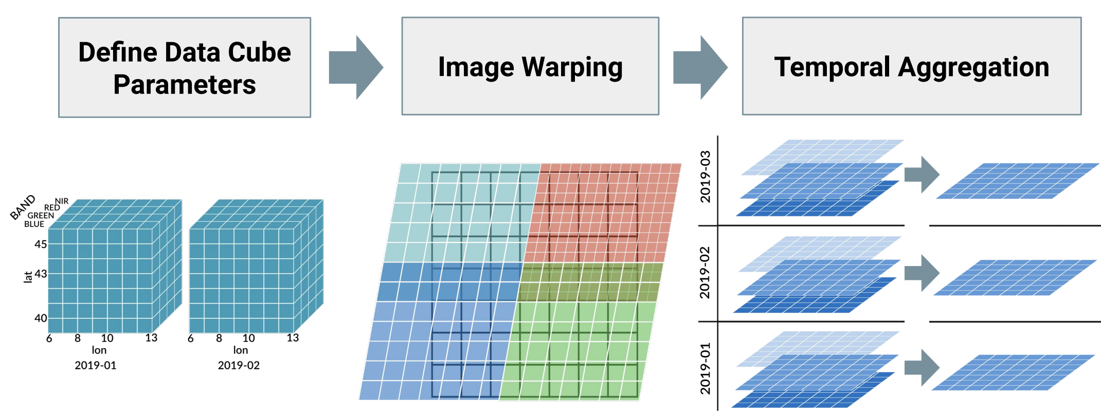 Important: There is no single correct data cube!
4. R ecosystem for analyzing satellite imagery (in the cloud)
R packages
- General packages for raster data analysis
- terra (Hijmans 2020) is a newer (faster) package that replaces raster (Hijmans 2019)
- Support two- or three-dimensional rasters
- Include lots of analysis tools
- Flexible package for spatiotemporal arrays / data cubes with arbitrary number of dimensions (Pebesma 2019)
- Supports raster and vector data cubes
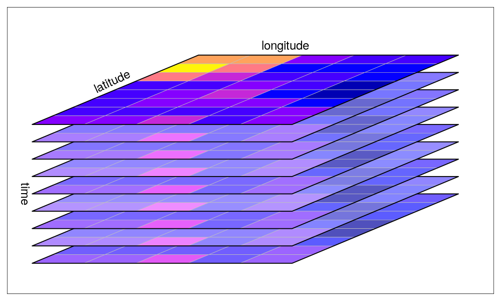
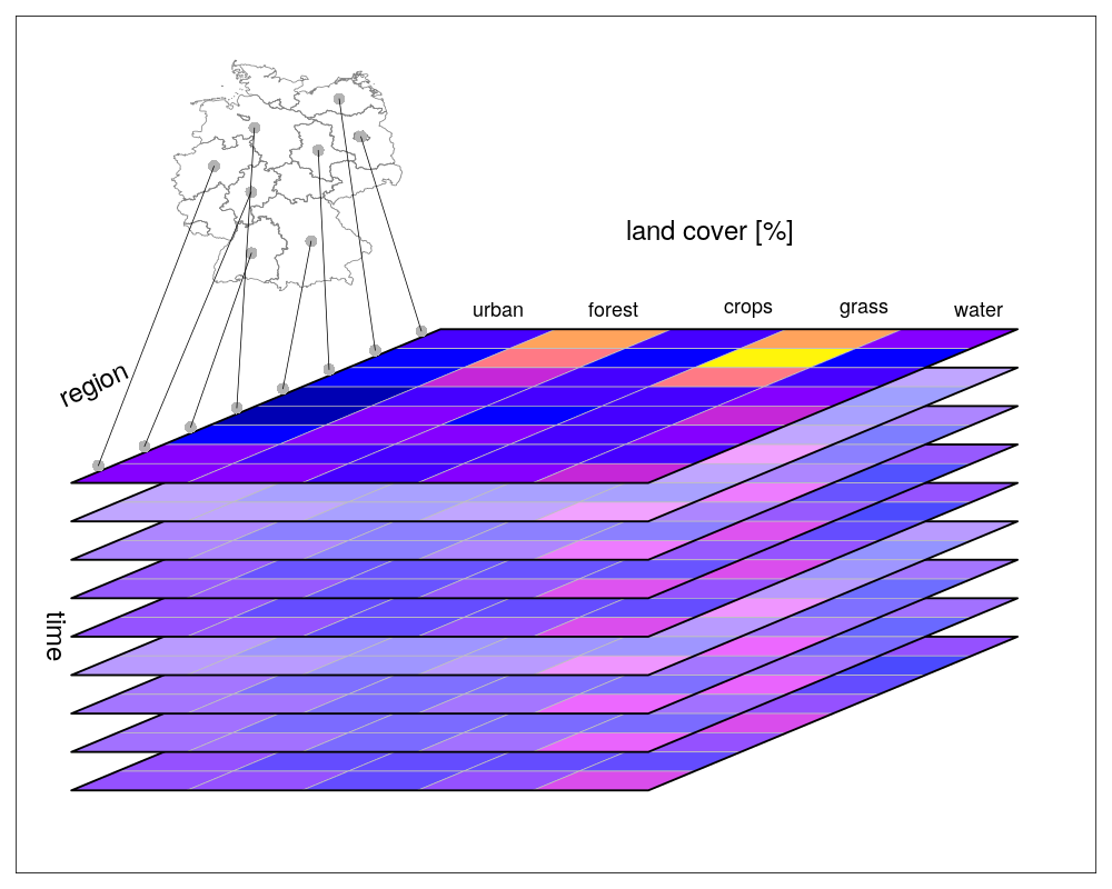
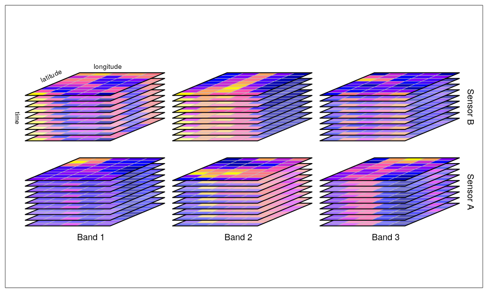
Imagery from https://r-spatial.github.io/stars
Creation and processing of four-dimensional (space, time, variable) data cubes from irregular image collections (Appel and Pebesma 2019)
Parallel chunk-wise processing
Documentation available at https://gdalcubes.github.io/

- Generic package for satellite image time series analysis (Simoes et al. 2021)
- Builds on top of previous packages
- Includes sophisticated methods with a focus on time series classification
- Documentation: https://e-sensing.github.io/sitsbook/

Imagery from https://github.com/e-sensing/sits
- rstac (Brazil Data Cube Team 2021): Query images from STAC-API services
- sp (Pebesma and Bivand 2005): replaced by sf and stars
- openeo (Lahn 2021): Connect to and analyse data at openEO backends
This tutorial focuses on the packages rstac and gdalcubes.
Live examples
Discussion
Discussion
Advantages
Access to huge data archives
Flexibility: You can do whatever you can do on your local machine
Powerful machines available
Open source software only
Disadvantages
Not free
GEE and others can be easier to use (some are free)
Your institution’s computing center might have more computing resources (for free)
Setup and familiarization needed
Depends on the existence of STAC-API services and imagery as COGs!
→ Which tools / platforms / environments are most efficient to use highly depends on factors like data volume, computational effort, data & method availability, effort needed to familiarization and reimplementation, and others.
Summary
Cloud-computing platforms contain lots of satellite data
Cloud storage differs from local storage
Technology and tools:
STAC (and STAC API!) for efficient and standardized search of spatiotemporal EO data
COGs allow efficiently reading parts of imagery, potentially on lower resolution
GDAL has everything for efficient data access on cloud storage
gdalcubes makes the creation and processing of data cubes from satellite image collections in R easier
Thanks!
Slides and notebooks:
https://github.com/appelmar/CONAE_2022
Contact: